Perusahaan ini terdaftar sebagai Free Member. Hindari melakukan pembayaran sebelum bertemu penjual atau melihat barang secara langsung. COD (Cash On Delivery) atau bertemu langsung dengan penjual merupakan metode transaksi aman yang kami sarankan.
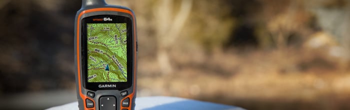
Garmin GPSMAP 64s memiliki layar warna 2,6″ yang mudah dibaca di bawah sinar matahari sekalipun, dan penerima satelit GPS dan GLONASS yang sensitif dengan antena Quad Helix untuk penerimaan yang superior. GPSMAP 64s dilengkapi juga dengan kompas elektronik 3-sumbu, barometric altimeter, konektifitas wireless untuk berbagi point, track dan rute ke sesama Garmin yang kompatibel. Garmin GPSMAP 64s sudah termasuk berlangganan gratis BirdsEye Satellite Imagery selama 1 tahun.
Find your way with the first quad helix GPS receiver that tracks both GPS and GLONASS satellites simultaneously. When using them together, the receiver has the ability to lock onto 24 more satellites than using GPS alone, ensuring you can “lock on” to a position more quickly.
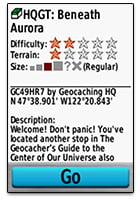
Start caching immediately by choosing from the 250,000 preloaded geocaches fromGeocaching.com. Caches come complete with hints and descriptions to get you started in the right direction.

Invite friends and family to follow your outdoor adventure in real time with Live Tracking. Send an invite via email or social media, and followers can view live data onGarmin Connect™.

Receive emails, texts and more, right on your device. GPSMAP 64s displays alerts from an iPhone® 4s or later wirelessly.
Experience a true representation of the outdoors with the included 1-year subscription to BirdsEye Satellite Imagery.
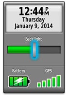
Go further with GPSMAP 64s’ long-lasting 16 hour battery life. Works with 2 AA batteries or the the optional NiMH battery pack, which as an added bonus, can be charged while inside the device.
iPhone is a trademark of Apple Inc., registered in the U.S. and other countries.
Physical & Performance: |
|
| Physical dimensions | 2.4″ x 6.3″ x 1.4″ (6.1 x 16.0 x 3.6 cm) |
| Display size, WxH | 1.43″ x 2.15″ (3.6 x 5.5 cm); 2.6″ diag (6.6 cm) |
| Display resolution, WxH | 160 x 240 pixels |
| Display type | transflective, 65-K color TFT, transflective |
| Weight | 9.2 oz (260.1 g) with batteries |
| Battery | 2 AA batteries (not included); NiMH or Lithium recommended |
| Battery life | 16 hours |
| Water rating | IPX7 |
| Floats | No |
| High-sensitivity receiver | Yes |
| Interface | high-speed USB and NMEA 0183 compatible |
Maps & Memory: |
|
| Basemap | Yes |
| Preloaded maps | no |
| Ability to add maps | Yes |
| Built-in memory | 4GB |
| Accepts data cards | microSD™ card (not included) |
| Waypoints/favorites/locations | 5000 |
| Routes | 200 |
| Track log | 10,000 points, 200 saved tracks |
Features & Benefits: |
|
| Automatic routing (turn by turn routing on roads) | Yes (with optional mapping for detailed roads) |
| Electronic compass | Yes (tilt-compensated 3-axis) |
| Touchscreen | No |
| Barometric altimeter | Yes |
| Camera | no |
| Geocaching-friendly | Yes (Paperless) |
| Custom maps compatible | Yes |
| Photo navigation (navigate to geotagged photos) | Yes |
| Hunt/fish calendar | Yes |
| Sun and moon information | Yes |
| Tide tables | Yes (with optional Bluechart) |
| Area calculation | Yes |
| Custom POIs (ability to add additional points of interest) | Yes |
| Unit-to-unit transfer (shares data wirelessly with similar units) | Yes |
| Picture viewer | Yes |
| Garmin Connect™ compatible (online community where you analyze, categorize and share data) | Yes |
| Additional |
Smart Notifications: yes Live Tracking: yes (with Garmin Connect™ Mobile) |
ISi Paket Penjualan :


